WHY JACKSONVILLE IS NORTHEAST FLORIDA'S MOST COMPETITIVE MARKET FOR AERIAL PARK PHOTOGRAPHY.
Jacksonville is the largest city by land area in the contiguous United States and the economic anchor of Northeast Florida. The metro area encompasses Duval County and its four surrounding counties — Clay, Nassau, St. Johns, and Baker — a combined region of nearly 1.7 million residents and one of the fastest-growing population bases in the Southeast. For RV parks and mobile home communities, this size and growth creates both opportunity and competitive pressure: a large, mobile, digitally active population searching for communities and sites, served by a dense and growing inventory of parks competing for the same visitors and residents.
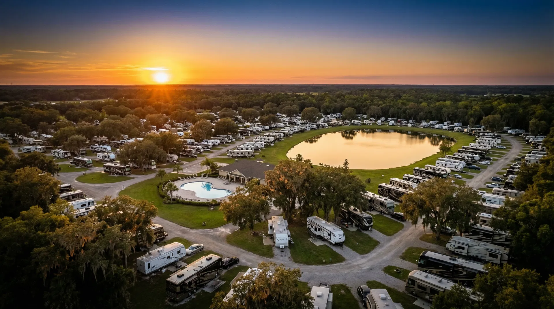
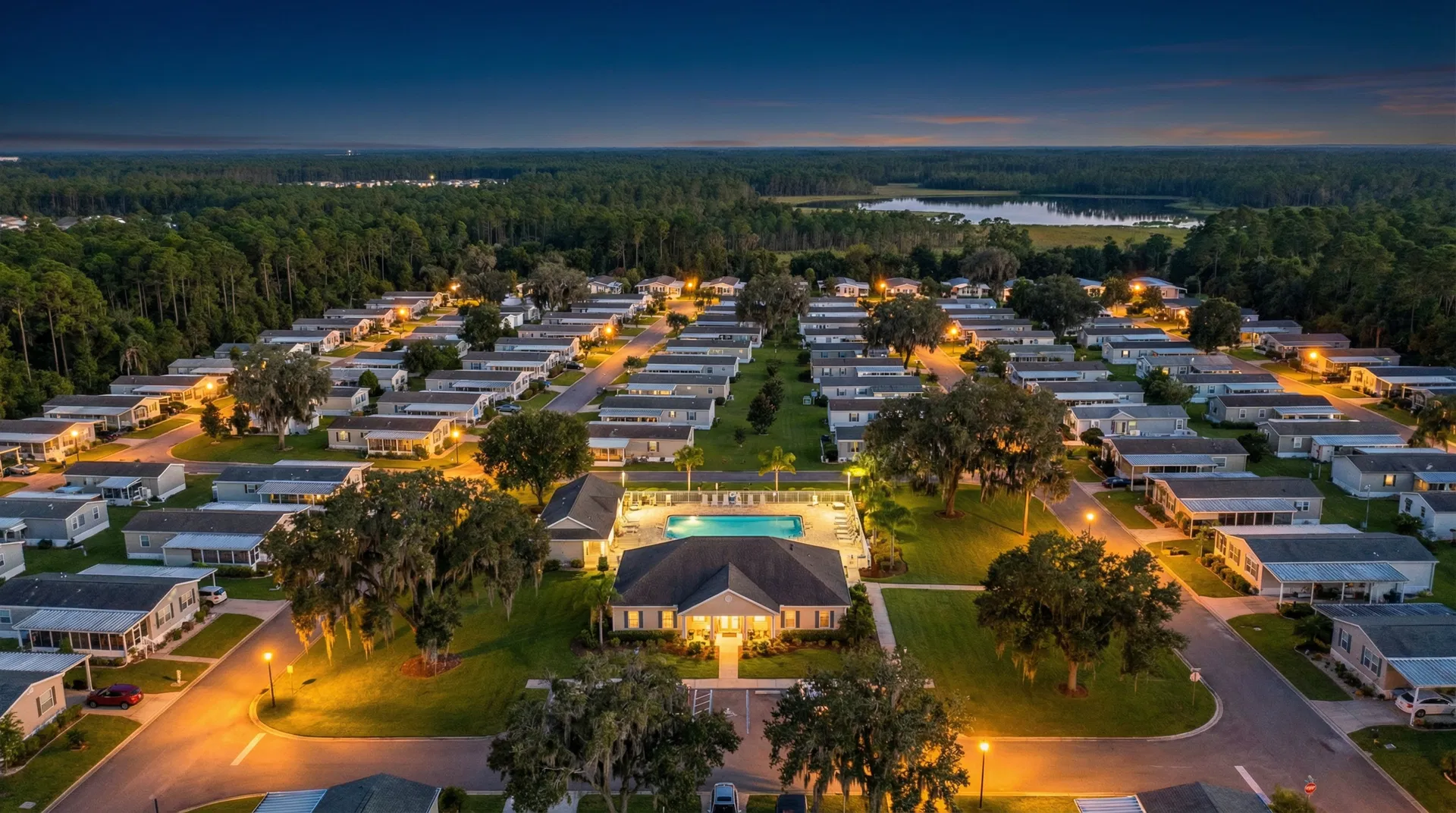
Jacksonville's RV park market spans several distinct corridors. Along the I-95 and I-10 corridors, parks capture high volumes of transient travelers passing through en route to South Florida or the Southeast interior. Near the St. Johns River and Intracoastal Waterway, waterfront RV resorts and campgrounds command premium rates and attract a loyal repeat-visitor base that shares compelling aerial video online at far above-average rates. In the Clay County and St. Johns County suburban fringe, mobile home communities serve a mix of workforce housing demand and retirees seeking the lifestyle of Northeast Florida at an affordable price point. Each of these park types benefits differently from aerial photography — and SkyVue knows how to shoot all three.
Jacksonville is one of the most active institutional acquisition markets for manufactured housing communities in North Florida. The combination of land availability, population growth, and a still-predominantly-fragmented ownership structure makes Duval and the surrounding counties a consistent target for private equity firms and REITs seeking mobile home park and RV resort acquisitions. Pre-acquisition aerial due diligence, orthomosaic mapping, and professional documentation packages have become standard requirements in the deal process — and Park View Aerials delivers them on timelines that keep Northeast Florida acquisitions moving.
Park View Aerials is FAA Part 107 certified and holds all required authorizations for commercial drone operations in the Jacksonville metro area, including airspace compliance near Jacksonville International Airport (JAX) and Naval Air Station Jacksonville — both of which require specific LAANC authorization. We cover Duval County and all surrounding counties within our standard 100-mile no-travel-fee radius. From Orange Park and Fleming Island in Clay County, to Fernandina Beach and Yulee in Nassau County, to Ponte Vedra and St. Augustine in St. Johns County — we serve the full Northeast Florida market without travel surcharges.
JACKSONVILLE-AREA PARKS
WE SERVE.
We serve mobile home parks and RV resorts throughout Jacksonville and the surrounding Northeast Florida metro area, including Duval, Clay, Nassau, St. Johns, and Baker counties:
Don't see your park listed? If you're located in Duval, Clay, Nassau, St. Johns, or Baker County, we serve your area. Call or submit a quote request for same-day confirmation.
FILL YOUR SITES FASTER IN ONE OF FLORIDA'S MOST COMPETITIVE PARK MARKETS.
Aerial Marketing Services for Independent Mobile Home Park & RV Park Owners in the Jacksonville Area
Running a mobile home park or RV resort in the Jacksonville market means competing against a large and growing inventory of properties — many of which are well-capitalized and professionally marketed. If your listing photos were taken on a phone three years ago, you are starting every guest or resident search at a disadvantage before they read a single word about your park. Aerial drone photography closes that gap immediately.
Park View Aerials works exclusively with mobile home parks and RV parks. We know the Jacksonville market and we know what prospective residents and guests in this area respond to online. We know how the St. Johns River looks at golden hour from 300 feet. We know how to frame a Clay County community that sits adjacent to a greenbelt. We know the angles that make a 1970s-era park look charming rather than dated, and the angles that make a newer resort look premium rather than just new. That knowledge is the difference between aerial photography that looks expensive and aerial photography that actually performs.
ACQUISITION DUE DILIGENCE FOR NORTHEAST FLORIDA'S MHP & RV PARK MARKET.
Serving Private Equity Firms, REITs, Family Offices, and Asset Management Companies Active in the Jacksonville Metro Area
Northeast Florida — anchored by Jacksonville and spanning Duval, Clay, Nassau, St. Johns, and Baker counties — is one of the most active mobile home park acquisition corridors in the Southeast. Before committing to a multi-million dollar acquisition in this market, your team needs property intelligence that can survive an investment committee review — and that holds up when your lender's appraiser runs the numbers.
Park View Aerials provides aerial documentation, orthomosaic mapping, and comprehensive property surveys in formats ready for inclusion in your investment memo and lender package. We have extensive knowledge of Northeast Florida's airspace requirements — including the controlled airspace around Jacksonville International Airport and NAS Jacksonville that requires LAANC authorization on every commercial flight.
EVERY SERVICE. EVERY COUNTY.
NO TRAVEL SURCHARGES.
Every service below is available across Jacksonville and the Northeast Florida metro area — Duval, Clay, Nassau, St. Johns, and Baker counties. No travel surcharges within 100 miles of Gainesville.
Aerial Photography — Still Imaging
High-resolution aerial photos of your full property capturing lot organization, amenity areas, natural surroundings, and approach angles. Delivered as web-optimized and print-ready JPEGs within 24 hours. Jacksonville-area parks especially benefit from aerial photography because of the region's mix of waterfront settings, mature tree canopies, and proximity to natural features that simply do not read from ground level.
Cinematic Video Production
1–2 minute professionally edited drone marketing video combining aerial flyovers, ground-level detail shots, and licensed music. Delivered as 4K MP4 within 5 business days, with a 30-second social cut in both horizontal and vertical formats. Jacksonville's large and active online community of RV enthusiasts and manufactured housing residents makes social video especially high-performing in this market.
Orthomosaic Mapping & Aerial Survey
Precision georeferenced property maps stitched from overlapping drone imagery. Delivered as GeoTIFF (GIS-ready) and JPEG. Ideal for acquisition due diligence, lot count verification, boundary clarity, and site planning. Standard deliverable for institutional buyers underwriting Jacksonville-area MHP and RV park acquisitions.
Acquisition Due Diligence Package
Comprehensive aerial documentation for pre-acquisition property assessment: orthomosaic map, 3D model, GPS-tagged infrastructure inspection photos, lot count verification, written assessment report, and organized digital delivery in investment-memo-ready format. Delivered within 48–72 hours. Covers the full Jacksonville metro area and surrounding counties.
Insurance Documentation & Damage Assessment
Dated, GPS-tagged aerial photo and video documentation of your property's full condition — structured for insurance underwriting and claims. Jacksonville and Northeast Florida properties face significant storm exposure from Atlantic systems; a current aerial baseline record is one of the highest-value proactive risk management steps a park owner can take. Emergency 24-hour delivery available for post-storm claims.
Ground Tour Video — Road-Level Property Survey
A systematic drive-through of every accessible road on your property, captured with a professionally mounted camera. Creates a first-person virtual tour experience that shows prospective guests and residents what it actually feels like to be at your park — road quality, site spacing, landscaping, and community atmosphere. Pairs powerfully with aerial video for a complete 360° marketing package.
SIMPLE. FAST.
PROFESSIONAL.
Get Your Free Quote
Submit a quote request online, call (352) 888-7627, or email us. Tell us your Jacksonville-area property address, what you need, and your timeline. We respond the same day — usually within a few hours.
We Schedule Your Flight
Once you approve the quote, we coordinate a flight window around your schedule and Florida's weather. We handle all FAA LAANC airspace authorizations — including controlled airspace near Jacksonville International Airport and NAS Jacksonville — before we ever leave our base.
On-Site Shoot
Our FAA-certified pilot arrives on time and works through a planned shot list covering your full property. Most Jacksonville-area park shoots take 1.5–3 hours. We work discreetly, avoid disrupting residents or guests, and adapt on site to capture anything that makes your specific property special — waterfront, tree canopy, proximity to landmarks.
Deliver in 24 Hours
Edited aerial photos delivered to your secure cloud link within 24 hours of the shoot. Video within 5 business days. Orthomosaic maps within 48–72 hours. All files are labeled, organized, and ready to upload directly to any listing platform, your website, or your investment package.
JACKSONVILLE PARK OWNERS: HERE'S WHY YOUR COMPETITORS ARE ALREADY DOING THIS.
A Competitive Market Demands Professional Visuals
Jacksonville is the largest city in Florida by land area, and its RV park and mobile home community market reflects that scale. The metro area has over 15 RV parks and 50+ mobile home communities competing for the same pool of prospective residents and guests. Many of the newer, larger, or investor-owned parks in the area have already invested in professional aerial photography and video — which means independent operators who have not are now visually outgunned on every listing platform they share space with.
The Social Media Opportunity Is Enormous
Northeast Florida has one of the most active regional communities of RV enthusiasts, manufactured housing residents, and outdoor recreation fans in the state. Facebook groups, NextDoor communities, and Instagram accounts focused on Jacksonville-area parks and the broader St. Johns River lifestyle generate enormous organic reach for well-produced visual content. A single professionally shot drone video posted to the right Jacksonville Facebook group can reach 10,000–30,000 local viewers at zero cost — and drive more direct inquiries in a week than a year of static listing photos.
Waterfront Parks Have an Untapped Visual Asset
Parks near the St. Johns River, Intracoastal Waterway, or any of the Nassau and St. Johns County waterfront corridors have a visual asset that most ground-level photography simply cannot communicate: proximity to water. From 300 feet up, the relationship between a park and its waterfront setting is immediately obvious and compelling. That single visual element — visible only from the air — is often the single most persuasive piece of marketing content a waterfront Jacksonville park can own.
WHAT JACKSONVILLE
PARK OPERATORS SAY.
"After SkyVue's aerial video, our website inquiries jumped 40% in the first month. Every park owner in Jacksonville needs this — the competition here is fierce and visuals are everything."
"The orthomosaic map they delivered was more accurate than anything our traditional surveyor produced. Saved us weeks on due diligence for our Northeast Florida acquisition."
SERVING JACKSONVILLE AND ALL SURROUNDING NORTHEAST FLORIDA COMMUNITIES.
Park View Aerials covers Jacksonville and the entire Northeast Florida metro area with no travel surcharges. Communities we regularly serve include:
Not listed? If your park is in Northeast Florida, we almost certainly serve your area — contact us to confirm same-day.
FREQUENTLY ASKED QUESTIONS ABOUT DRONE PHOTOGRAPHY IN JACKSONVILLE, FL.
READY TO SHOW YOUR JACKSONVILLE PARK FROM ITS BEST ANGLE?
Whether you own an RV resort on the St. Johns River, a mobile home community in Clay County, or a campground serving Jacksonville's I-95 traveller corridor — or you are an institutional investor underwriting your next Northeast Florida acquisition — Park View Aerials delivers the aerial photography, video, and data you need on a timeline that works.
Get your free quote within 24 hours. No pressure, no contracts until you are ready. View all services & packages →
◄ Back to All Service Areas